| |

List of US statesThe United States of America (USA) is a country in North America. The United States of America has fifty states, one district, five major unorganized territories, 326 Indian reservations, and a few possessions. The United States covers 9.8 million square kilometres, which makes it the world's third or fourth largest county in terms of area. 
The United States shares substantial land borders with Canada and Mexico to the north and south and modest maritime borders with the Bahamas, Cuba, and Russia. With a population of 331 million people, it is the world's third most crowded country. Since 1871, the United States has been the world's largest economy. EtymologyThe word "America" was first recorded in 1507 when it appeared on a global map created by German cartographer Martin Waldseemuller. In commemoration of Amerigo Vespucci, the name is written in huge characters on his map in what is now known as South America. His discovery of an unknown landmass, rather than Asia's eastern border, was credited to the Italian adventurer. Gerardus Mercator, a Flemish geographer, applied "America" to the entire Western Hemisphere on his globe map in 1538. The list of US states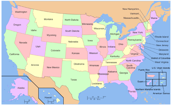
Explanation of Few US States1. Alabama:Alabama is a state in the United States' South-eastern region, bordered to the north by Tennessee, east by Georgia, south by Florida and the Gulf of Mexico, and west by Mississippi. Alabama, the 22nd state to join the union in 1819, is in the southern United States known as the "Heart of Dixie." In what is now Alabama, people have been living there for at least 10,000 years. In the 16th century, Europeans began to explore the area. Alabama's economy was based on cotton and slave labour throughout the first part of the nineteenth century. Segregation of blacks and whites persisted in much of the South after the war. In the mid-twentieth century, Alabama was the epicentre of the American Civil Rights Movement. Jobs in aerospace, agriculture, auto industry, and the service sector fuelled the state's economy in the early twenty-first century. 2. Arizona:Arizona is the 14th most populous state and the sixth-largest in the United States. It is situated in the southwestern part of the United States. On February 14, 1912, the state was granted statehood, making it the 48th to join the union. Its five bordering states are Nevada, New Mexico, Utah, California, and Colorado. Arizona (often known as the Copper State) is divided into 15 counties. Phoenix is the state capital. Arizona's postal abbreviation is AZ. Mexico relinquished much of this region to the United States in 1848 after being defeated in the Mexican-American War. The Gadsden Purchase purchased the state's southernmost section in 1853. 3. Alaska:The state is well-known for its fishing, mining, and oil industries, but its most recent industry is the peony. This state is located in the northwest region of the United States' west coast. On the north-western tip of North America's continent is a vast peninsula known as Alaska. Alaska's westernmost section is in the Eastern Hemisphere since the 180th meridian runs across the Aleutian Islands. As a result, Alaska is technically in both hemispheres. The Beaufort Sea and the Arctic Ocean border Alaska at north; the Yukon Territory and British Columbia province border Alaska at east; the Gulf of Alaska and the Pacific Ocean border Alaska are on the south. The Bering Strait and the Bering Sea border Alaska are on the west, and the Chukchi Sea border Alaska are on the northwest. Juneau, the state capital, is located near the panhandle region in the state's southeast. 4. Arkansas:Arkansas gets its name from the Osage language, a Dhegihan Siouan language, and relates to the Quapaw people, who are related to the Osage. Arkansas is the 33rd most populous and 29th largest of the 50 US states. Arkansas is located in the United States' south-eastern area. On June 15, 1836, the state was granted statehood, making it the 25th state to join the union. Six other countries border Arkansas (Oklahoma, Tennessee, Texas, Louisiana, Mississippi, and Missouri). Arkansas is renowned as the "Natural State" and the "Land of Opportunity" because of its 75 counties. Little Rock is the state capital. Arkansas is abbreviated as AR in the postal system. The state's north-western section, which includes the Fayetteville-Springdale-Rogers Metropolitan Area and the Fort Smith Metropolitan Area, is a demographic, educational, and economic centre. 5. California:California is a Western United States' state. It is located on the east of Nevada, on the southeast by Arizona, on the west of the Pacific Ocean, on the north by Oregon, and the south of the Mexican state of Baja California. It is the most populous and third-largest U.S. state by area, with about 39.5 million persons spread throughout a total area of around 163,696 square miles (423,970 km2). It is also North America's most crowded sub-national entity and the world's 34th most crowded. The Greater Los Angeles area and San Francisco Bay area are the country's second and fifth most crowded urban areas, with over 18.7 million persons in the former and over 9.6 million in the latter. The economy of California's is the world's largest sub-national economy, has a gross state output of $3.2 trillion compared with 2019. It would be the 37th most crowded country and the fifth-largest economy in the world by 2020. 6. Colorado:Colorado is a state located in the Western United States. The adjective "Colorado" comes from the Spanish word "ruddy," which describes the hue of red sandstone. On February 28, 1861, the Territory of Colorado was formed, and on August 1, 1876, U.S. President Ulysses S. Grant accepted Proclamation 230, admitting Colorado as the 38th state in the Union. Colorado is also known as the "Centennial State" because it became a state one hundred years after the United States Declaration of Independence was accepted. Colorado is the eighth-largest and most crowded state in the United States. It consists major part of the Southern Rocky Mountains, the Colorado Plateau's north-eastern section, and the western edge of the Great Plains. Colorado's population was 5,773,714 people in the 2020 United States Census, up 14.80 per cent from the 2010 census. The Linden Meier Site, which contains items dating from around 9200 BCE to 1000 BCE, has been occupied by Native Americans for more than 13,000 years; the eastern side of the Rocky Mountains was an important migration route for early peoples that migrated throughout the Americas. 7. New York:United States state New York is one of the original Thirteen Colonies, the first thirteen states to form part of the United States. On its northern and western borders, New York is bordered by Lake Ontario, while its eastern border is bordered by New Jersey, while Pennsylvania borders its western border. New York's eastern border is bordered by Pennsylvania on the west, while Lake Erie and Canada border its western border. New York was formerly known as New Netherland, a colony of the Dutch Empire established in the early 1700s. During the Anglo-Dutch Wars, it was captured by an English fleet and incorporated into the British Empire. Nearly half of the Dutch colony was ceded to the English colonies that bordered the Netherlands. During the American Revolutionary War, the Battle of Long Island, the Battle of Saratoga, and many other key battles were fought in New York, and later many black individuals were brought to the state through the slave trade and forced to work for white colonists. U.S. Census Bureau data shows that New York ranked fourth in population among all U.S. states as of 2005. New York has a population of 19,297,729 people. 8. New Jersey:There is a United States state of New Jersey, located in the Mid-Atlantic and North-eastern regions of the country State of New York, which borders it on the north and eastern side. Delaware and Delaware Bay border it on the west, south, southeast and east sides. The Atlantic Ocean borders it on the east, southeast, and south sides have a surface area of 7,354 square miles (19,050 km2). It is the fifth smallest state in terms of land area and the 11th-most populous and most densely populated. Trenton is New Jersey's state capital, but New York is its largest city by population. Apart from Warren County outside of New York City and Philadelphia, the state's largest metropolitan area is part of Greater New York. Native Americans dominated New Jersey for at least 2,800 years before Europeans arrived in the early 17th century, with the Lenape was the dominant population.
Next TopicList of Pirates of the Caribbean Movies
|
 For Videos Join Our Youtube Channel: Join Now
Feedback
- Send your Feedback to [email protected]
Help Others, Please Share


