| |

NCERT Solutions Class 6 Social Science GeographyChapter 7: Our Country - India1. Answer the following questions briefly.a. Name the major physical division of India. Answer: India has diversity of physical divisions.
b. India shares its land boundaries with seven countries. Name them. Answer: The seven countries are as follows:
c. Which two major rivers fall into the Arabian Sea? Answer: Narmada and Tapi are the two major rivers that fall into the Arabian sea. d. Name the delta formed by the Ganga and the Brahmaputra. Answer: The Sunderban delta is formed by the Ganga and the Brahmaputra. e. How many States and Union Territories are there in India? Which states have a common capital? Answer: There are 28 states and 8 union territories. The states with the common capital are: 1. State: Punjab and Haryana Common Capital: Chandigarh Note: The data of the number of states and union territories is the latest update as of 2022.f. Why do a large number of people live in the Northern plains? Answer: Northern Indian plains is formed by the alluvial deposits of the three rivers, the Indus, the Ganga and the Brahmaputra and their tributaries. These rivers provide fertile land for the cultivation. Hence, a large number of people live in the Northern plains. g. Why is Lakshadweep known as a coral island? Answer: Coral islands are formed from the corals. Corals are the skeleton of the tiny marine animals called Polyps. These skeletons grows higher and higher after other polyps grow on it. Hence, Lakshadweep island is known as coral island. 2. Tick the correct answers.a. The southernmost Himalayas are known as
Answer: i. Shiwaliks Explanation: Shiwaliks lies in thesouthernmost Himalayan range. b. Sahyadris is also known as
Answer: ii. Western Ghats Explanation: Sahyadris is also known as Western Ghats because it bordersthe plateau in the west. c. The Palk Strait lies between the countries
Answer: ii. India and Sri Lanka Explanation: The Palk Strait lies between the two countries, India and Sri Lanka. d. The Indian islands in the Arabian Sea are known as
Answer: ii. Lakshadweep Islands Explanation: Lakshadweep Islands are the Indian islands in the Arabian Sea. e. The oldest mountain range in India is the
Answer: i. Aravali hills Explanation: Aravali hills is one of the oldest mountain range in India. 3. Fill in the blanks.
Map skills1. On an outline map of India, mark the following.
Answer: The map is shown below: 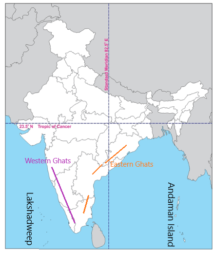
|
 For Videos Join Our Youtube Channel: Join Now
Feedback
- Send your Feedback to [email protected]
Help Others, Please Share


