| |

Plateau DefinitionPlateaus are defined as flat or nearly flat areas of elevated land with steep or gentle slopes on one or more sides. They rank among the planet's most amazing and interesting natural wonders. They are often located between mountains or hilly regions and valleys. Plateaus are found all over the world, from the Andean Plateau in South America to the Tibetan Plateau in Asia. The several plateau forms, their formation processes, and their attributes will all be covered in this article. 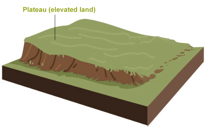
Formation of PlateausPlateaus are formed through a variety of geological processes, but they all share one common feature: they are elevated above the surrounding terrain. Some of the most common ways plateaus are formed include:
The movement of tectonic plates can cause large sections of the Earth's crust to rise and form plateaus. This process is known as uplift. Uplift can occur due to compression, tension, or shear forces in the Earth's crust. Examples of uplifted plateaus include the Tibetan Plateau and the Colorado Plateau.
When volcanoes erupt, lava and other volcanic materials can build up on the surface, forming a flat or gently sloping landscape. Over time, these materials can cool and solidify into a plateau. Examples of volcanic plateaus include the Deccan Plateau and the Columbia Plateau.
Plateaus can also emerge as a result of erosion. When rivers and other water bodies flow across the surface of a plateau, they can carve out valleys and canyons, breaking down the surface into a series of smaller plateaus. Dissection is the term for this action. A dissected plateau is one like the Appalachian Plateau. Types of PlateausThere are three main types of plateaus: volcanic plateaus, uplifted plateaus, and dissected plateaus:
These plateaus are formed due to volcanic activity. When lava and other volcanic materials cool and solidify on the surface, they form a flat or gently sloping landscape. The Deccan Plateau in India and the Columbia Plateau in the United States are two examples of volcanic plateaus.
These plateaus are formed when tectonic forces push up large sections of the Earth's crust. As these sections rise, they form a flat or gently sloping surface. An example of an elevated plateau is the Colorado Plateau in the United States.
These plateaus are formed when erosion breaks down the surface of a plateau into a series of smaller plateaus and valleys. A dissected plateau is one like the Appalachian Plateau in the United States. Characteristics of PlateauA plateau is a type of landform that is characterized by a flat, elevated area of land with a relatively level surface that rises sharply above the surrounding terrain. The following are some essential traits of a plateau:
The Value of PlateausThe world's plateaus provide several advantages for both humans and the subjective well-being of the Earth's surface. The following are some noteworthy advantages of plateaus:
The majority of plateaus contain picturesque spots or other attractions that draw tourists. The enormous cannons and countless waterfalls that are present in the majority of high plateaus are ideal illustrations of tourist attractions on plateaus. Residents in these locations can profit from the sites' foreign income thanks to the attractions. The Nine Main Plateaus of Peninsular India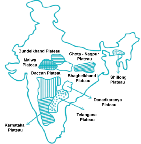
1. The Marwar UplandDue to its location to the east of the Aravali Range, this is also known as the Upland of Eastern Rajasthan. This region slopes down eastward and has an average elevation between 250 and 500 meters above sea level. Sandstone, shales, and limestone from the Vindhayan era make up its composition. Before it merges with the Chambal River, the Banas River travels for around 400 kilometres beginning in the Aravali Mountains. The Banas river and its tributaries have transformed the region into a rolling plain via erosion. 2. The Central HighlandsThe Madhya Bharat Pathar is an area located east of the Marwar Upland. The majority of it is made up of the Chambal River's basin, which runs through a rift valley. Its two principal tributaries are the Sindh and the Parhati. It is an open, undulating plateau formed of ancient rocks that are broken up by sandstone hills with rounded tops. There are substantial forests here. The ravines or badlands of the Chambal River are to the north. 3. The Upland of BundelkhandThe Bundelkhand Gneiss is an old dissected upland south of the Yamuna River between the Madhya Bharat Pathar and the Vindhyan Scarplands. It is composed of granite and gneiss. The area is known as Bundelkhand Upland. This upland, which encompasses four districts in Madhya Pradesh and five districts in Uttar Pradesh (Jalaun, Jhansi, Lalitpur, Hamirpur, and Banda), is around 54,560 square kilometres in size. (Datia, Tikamgarh, Chhatarpur, and Panna). With an average height of 300-600 m above sea level, this area falls down from the Vindhyan Scarp towards the Yamuna River. A mass of rounded hummocky hills constructed of granite and sandstone can be used to identify the location. The Ganga-Yamuna alluvium covers the system in the northwest and northeast, while the Deccan Trap covers it in the southwest. It has become an undulating terrain that is unsuitable for farming as a result of the rivers' erosional activities. The terrain in the area has ageing topography. Just 3.6% of the territory is over 450 m and around 67.7% of it is below 300 m. Streams like the Betwa, Dhasan, and Ken have sculpted waterfalls, stony banks, and steep gorges. 4. The Malwa PlateauThe Malwa Plateau is surrounded by the Aravali Mountains in the west and a sharp scarp that looks out across Bundelkhand in the east. It is frequently fashioned like a triangle based on the Vindhyan Hills. The plateau is endowed with complicated geology, and almost all of the peninsular groups are represented. The Bay of Bengal drainage system empties into this plateau, while the Narmada, Tapi, and Mahi drainage systems pour into the Arabian Sea. (Chambal and Betwa, joining the Yamuna). It is 530 kilometres long and 390 km wide, covering an area of 1,50,000 sq km. 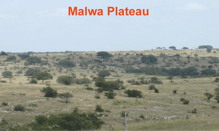
The Chambal and many of its right bank tributaries, including the Kali, Sindh, and Parbati, drain it in the north. It also comprises the Ken, Betwa, and upper courses of the Sindh. It is made up of a sizable lava flow and has black dirt all over it. From 600 meters in the south to less than 500 meters in the north, the average height drops. With flat-topped hills and rivers passing across it, the landscape is undulating. One distinguishing characteristic of the plateau is the Chambal ravines in the north. 5. The BaghelkhandEast of the Maikal Range lies a region known as the Baghelkhand, which is composed primarily of granite on the east and limestones and sandstones on the west. It has a surface size of around 1.4 lakh sq km. Son River borders it to the north, while sandstone and limestone synclinal valleys and anticlinal hills are found to the south. The Mahanadi River system and the Son drainage system are separated by a body of water in the plateau's centre. The area has an irregular topography with a typical elevation range of 150 m to 1,200 m. The main physiographic characteristics are the Vindhyan sandstone scarps between the Ganga plain and the Narmada-Son valley. The trough axis is not far from the locations of the Bhanrer and Kaimur. The overall horizontality of the strata demonstrates that there haven't been any significant disturbances in this region. 6. The Plateau of Chotanagpur:The Chotanagpur plateau constitutes the north-eastern protrusion of the Indian Peninsula and is located east of Baghelkhand. It is mostly found in Jharkhand, the northernmost portion of Chhatisgarh, and the Purulia district of West Bengal, covering an area of around 87 thousand square kilometres. Northwest of the plateau, the Son River empties into the Ganga. The plateau is typically 700 meters above sea level. Gondwana rocks dominate this plateau, with sections of Archaean granite, gneisses, and Deccan Lavas interspersed. Almost a succession of plateaus rising at various elevations make up the Chotanagpur plateau. The Pat lands region in the middle of the continent has the greatest average elevation, which is around 1,100 meters (high-level laterite plateau). The ground gradually lowers in all directions from here in a sequence of steps denoted by waterfalls spanning the rivers. The plateau has a radial drainage pattern because it is drained by various rivers and streams that flow in different directions. Widespread drainage basins have formed along rivers, including the Damodar, Subamrekaha, North Koel, South Koel, and Barkar. In a rift valley running from west to east across the centre of this area lies the Damodar River. The Gondwana coal resources, which supply the majority of the coal to India, are located here. Averaging 600 meters above mean sea level, the Hazaribagh plateau is situated north of the Damodar River. The easternmost hill, Parasnath, rises to 1,366 metres on this plateau. Granite and gneisses dominate the region, with quartz rocks dominating the slopes. Due to extensive erosion, it resembles a peneplain. On the Ranchi Plateau, south of the Damodar Valley, the elevation is around 600 meters above mean sea level. The western region is where the height is greatest, with towering mesa pats that sharply ascend to an elevation of roughly 1100 m. The heights of the Netarhat Pat and Goru are 1,119 and 1,142 metres, respectively. Where Ranchi (661 m) is located, the terrain is mostly rolling. It is occasionally interrupted by conical hills and monadnocks. The Rajmahal Hills, which define the Chotanagpur Plateau's north-eastern border, are primarily formed of basalt and are covered with lava flows. They go from north to south and gain an average of 400 meters in altitude (the highest mount is 567 m). There are several plateaus made by the division of these hills. 7. The Meghalaya PlateauBeyond the Rajmahal Hills, to the northeast, are the rocks that make up the peninsular plateau of India, which together constitute the Meghalaya or Shillong plateau. The Garo-Rajmahal Gap, a significant chasm between this plateau and the main block of the peninsular plateau, divides them. The Ganga's sedimentary deposits eventually filled the gap that was created by down-faulting. This plateau, which covers an area of roughly 35,000 square kilometers, was mostly created by Archaean (Dharwarian) quartzites, shales, and schists, with intrusions of granite and some simple silt. The plateau dips southward into the Surma and Meghna rivers and northward towards the Brahmaputra valley. Its western border roughly corresponds with the border of Bangladesh. The Khasi-Jaintia Hills (1,500 m), Mikir Hills (900 m), and Garo Hills (900 m) are the names of the plateau's western, middle, and eastern portions, respectively. (700 m). Shillong is the plateau's tallest mountain (1,961 m). 8. The Deccan PlateauWith a total area of more than five lakh square kilometers, the Deccan Plateau is the largest portion of the Indian Peninsular Plateau. The Satpura and Vindhya in the northwest, the Mahadev and Maikal in the north, the Western Ghats in the west, and the Eastern Ghats in the east ring this triangular plateau. It is 600 meters above sea level on average, rising to 1000 meters in the south and 500 meters in the north. The movement of its principal rivers, including the Mahanadi, the Godavari, the Krishna, and the Cauvery, show that it generally slopes from west to east. This plateau has been further separated by these rivers into several smaller plateaus, which are listed as follows: (a) The northern portion of the Deccan Plateau is made up of the Maharashtra Plateau, which is located in Maharashtra. Basaltic rocks that were formed by lava underlie a large portion of the area. Weathering has given the land the appearance of a rolling plain. The Deccan Trap topography was created as a result of the horizontal lava flows. Wide and shallow valleys of Godavari, Bhima, and Krishna are surrounded by flat-topped, steep-sided hills and mountains. The Ajanta range is situated south of the Tapi River. Regur, a soil of black cotton, covers the whole region. (b) The Maharashtra Plateau lies south of the Karnataka Plateau, also referred to as the Mysore Plateau. It is a rolling nation with an average height of 600-900 m and is mostly composed of Archaean strata. Several rivers that emerge from the Western Ghats deeply cut it. The Tungabhadra and Cauvery River heads are located there. The general trend of the hills is parallel to or cut through by the Western Ghats. The tallest peak, Mulangiri, in the Baba Budan Hills of the Chikmagalur district, is 1913 metres high. The two halves of the plateau go by the names of Malnad and Maidan. Kannada for "the Malnad" is "high country." Deep valleys covered with thick trees cut through it. The Maidan is made up of an undulating plain and a little granite hill on the other side. The plateau in the south narrows and joins with the Niligiri highlands between the Western Ghats and the Eastern Ghats. (c) At an average height of 500-600 m, the Telangana plateau in Andhra Pradesh is made up of Archaean gneisses. In comparison to its northern twin, the southern section is taller. The region is drained by the Godavari, Krishna, and Penneru river systems. The Ghats and the Peneplains are the two main physiographic divisions of the whole plateau. 9. The Plain of ChhattisgarhAmong the immense expanse of plateaus and hill ranges that makes up the Peninsular plateau, the Chhattisgarh plain is the only plain deserving of the term. It is a dip with a saucer shape that the Mahanadi's upper basin drains. The whole basin is between the Maikala Range and the Orissa Hills. The area was previously governed by the Haithaivanshi Rajputs, whose 36 forts (Chhattisgarh) are where the name of the region comes from. The Cuddapah age is reflected in the almost horizontal strata of limestone and shales that make up the basin. From 250 meters in the east to 330 meters in the west, the plain's general elevation fluctuates.
Next TopicPolitical Party Definition
|
 For Videos Join Our Youtube Channel: Join Now
Feedback
- Send your Feedback to [email protected]
Help Others, Please Share


