WHICH IS THE LARGEST RIVER IN THE WORLD?
The largest river in the world is the Nile River of Northeastern Africa. The river has a total length of about 6,650 km (4,130 m) with a total drainage area of approximately 3,349,000 sq. km (1,293,000 sq. miles) which is about 10% of Africa's total area. As per some beliefs, the river got its name from the Latin and ancient Greek languages. The river starts from the south of the equator and continuously flows in the northward direction from Northeastern Africa, and in the end, it drains into the Mediterranean Sea. According to some researchers, the Amazon River is the largest river on the planet as per the measure of cubic meters flowing annually. The river serves as the primary supplier of water resources in Sudan and Egypt. The Nile River flows in eleven countries. The average discharge of the river is 3.1 million liters per second.
COURSES
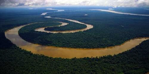
The Nile River is the longest river on the planet that flows between Lake Victoria and the Mediterranean Sea. But the quantity of water carried by the river is much little compared to other major rivers of the world. The discharge along with the main stem of the river basin depends on various factors. They include weather conditions, evaporation and evapotranspiration, diversions, and groundwater flow. The complex river basin is the prime cause of it.
Sources
The White Nile and the Blue Nile are the two major sources of the Nile's formation. The sources of both these tributaries are Luvironza River and Lake Tana, respectively, in the Gilbel Abbay watershed of the highlands of Ethiopia. These tributaries of the Nile begin from equatorial East Africa and Ethiopia, respectively. Both of these rivers run through the western sides of the East African Rift.
In 2010, a new source of about 6,758 km was found by the exploration party in the Nyumgwe Forest. At the Luveronza River, the most remotely located source from the Mediterranean outflow is found. It is believed that the first drop of the Blue Nile's water was originated in Gish Abay.
- Uganda: The Nile runs out of Lake Victoria from Ripon Falls, located close by Jinja city of Uganda. At its point of origin, the river is called the Victoria Nile. After it, the river flows north to Lake Kyoga. The beginning of the river's rearmost part happens from the western coast of Lake Victoria. After it, the Nile moves first to the Masindi Port located in the west direction from where it spins to the north. This movement of the river makes an arch to the east and north up to Karuma Falls. The river reaches the northern shores of Lake Albert after flowing through Murchison Falls. At Lake Albert, the Nile forms a significant river delta. The river flows continue towards the north through Uganda and are popularly known as the Albert Nile.
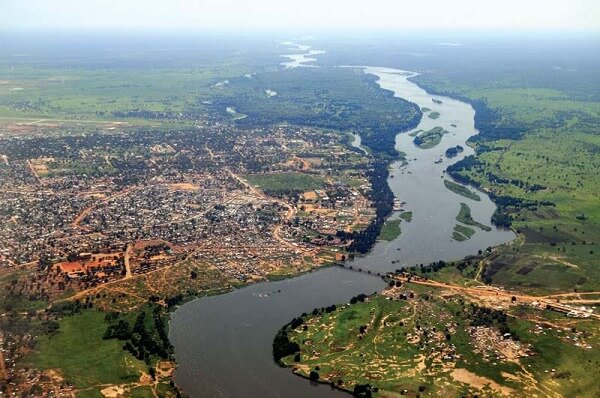
- South Sudan: In this town, the river flows just south of Nimule, called Bahr al Jabal, which means a mountain river. Here, the river flows together with the Achwa River. The Bahr al Ghazal meets with the Bahr al Jabal at a small lagoon known as Lake No. After this confluence, the Nile is called the Bahr al Abyad or the White Nile. It is because of its white color due to the suspension of white clay into its water. When the river gets flooded, it fertilizes the soil by leaving a rich silty deposit. But after the construction of The Aswan Dam in Egypt in 1970, the river does not get flooded. From the Bahr al Jabal, an anabranch river named Bahr el Zeraf flows which again joins the White Nile. The water flows in the Bahr al Jabal remain constant throughout the year at Mongalla, South Sudan. After leaving Mongalla, the river enters the Sudd region, where more than half of its water gets lost in evaporation and transpiration. From Sudd, the Nile joins the Sobat River at Malakal. The upstream of the White Nile contributes about 15% per annum in the river's total outflow. At Lake Kawaki, Malakal, the Nile gets its peak flow in October and minimum flow in April. This fluctuation in the flow arises due to the substantial variation in the Sobat. The White Nile contributes 70 to 90 percent of the total discharge from January to June when the dry season occurs.
- Sudan: In Sudan, the White Nile joins the Blue Nile by flowing through north to Khartoum. The Nile has a specific course in Sudan because of two reasons. The first is the river flow over six groups of cataracts which starts from the Aswan and ends at Sabaloka. And the second is the river flows in the reverse direction of over 300 km towards the southwest instead of north. It is due to the tectonic upliftment of the Nubian Swell. This 'S'-shaped bend of the river is known as the "Great Bend of the Nile". At Al Dabbah, the river returns to its path northward. The Nile meets with Lake Nasser (Lake Nubia) through the north of Sudan. The major part of this lake flows through Egypt.
- Egypt: The River enters the Egyptian region below the Aswan High Dam at Lake Nasser's northern limit. From the north of Cairo, the Nile separated into two distributaries or branches named the Rosetta and the Damietta. These two branches flow to the west and the east, respectively, where they feed the Mediterranean and form the Nile Delta.
TRIBUTARIES
The tributaries of the world's longest river Nile, are as follows:
- Blue Nile: The Blue River originates from Lake Tanain in the highlands of Ethiopia. This tributary joins the White Nile after flowing 1,400 km to Khartoum, where they both lead to the formation of the Nile River. About 90% of water and 96% of the transported sediments of the Nile River originates in Ethiopia. From this, about 59% of water is supplied by the Blue Nile, and the rest is by the Tekeze, Sobat, Atbarah, and other small tributaries. The erosion and transportation of silt in the Blue Nile take place during the rainy season in the summer when the plateau gets a high amount of precipitation. The flow of the rivers that drain into the Nile is weaker for the rest of the year. The tributaries also dry during droughts or dry seasons. The Blue Nile creates a large natural variation in the main river due to the change in its annual water flow cycle. Before the development of dams on the river, the changes by a factor of 15 occurs in the annual discharge at Aswan. During the wet season in late August and early September, the river gets the highest flow of over 5,663 m³/s, while during the dry season in late April and early May, it gets the lowest flows of about 113 m³/s.
- Red Nile: The second major tributary of the Nile is the Atbara River, followed by the Blue Nile. It is commonly known as the Red Nile. The river springs from Ethiopia in the north of Lake Tana. It covers a length of about 800 kilometers (500 mi). The Red Nile flows only when Ethiopia gets monsoon, and after the departure of the monsoon, the river gets dry very rapidly. This dry period of the river continues from January to June. During this period, the river got dried up to the North of Khartoum.
- Bahr el Ghazal and Sobat River: As per their discharge, these two rivers are the most important tributaries of the White Nile. The river Bahr al Ghazal has the largest drainage basin among all sub-basins of the Nile. It has a total area of 520,000 sq. km (200,000 sq. mi). The river contributes a very small quantity of water, i.e., about two m³/s in a year. This is because a huge amount of Bahr al Ghazal's water being lost in the wetlands of Sudd.
On the other hand, the Sobat River meets the Nile near Lake No. It covers a total area of 225,000 sq. km (86,900 sq. mi) and contributes 412 m³/s water in a year to the main river. The Sobat River takes sediments with its water during the floods in the river, which greatly changes the color of the White Nile.
- Yellow Nile: It is a former tributary of the Nile. It connected the Ouaddai Highlands, located in eastern Chad, with the Nile River valley in 8000 to 1000 BCE. At present, the lefts of it are known as Wadi Howar. It flows through Gharb Darfur, which bordered with Chad in its north. Then, Wadi meets with the main river in the Great Bend at its southern point.
THE NILE DELTA
The formation of the Nile Delta takes place in the lower parts of Egypt, where the river ends into the Mediterranean Sea. It is one of the largest river deltas on earth. Its formation starts in Cairo. The area covered by delta from west to east, i.e., from Alexandria to Port Said, is 240 km, while from North to South, it is 160 km. The deltaic region has very fertile land which is filled with nutrients and is highly suitable for agriculture.
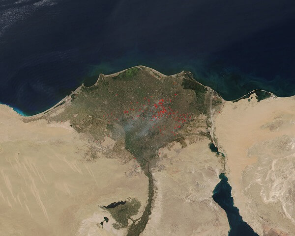
- Population: The delta region of the river gives shelter to about 39 million Other than the major cities, the average population density here is 1,000 per sq. km or more. The largest city of the Nile Delta is Alexandria, with a total population of more than 4.5 million. Some other major cities of the region are Zagazig, Port Said, Mansura, Shubra El Kheima, Tanta, etc.
- Wildlife: During the autumn season, the Nile River gets covered with red lotus flowers. In the Upper Nile (South), Egyptian Lotus grows, while in the Lower Nile (North), Papyrus Sedge grows (this is a rare flower and now is not so plentiful). The delta of the river is highly known for the presence of several thousand water birds. It is the home of the world's largest concentration of whiskered terns and little gulls. Other than this, birds like Kentish plovers, cormorants, ibises, grey herons, egrets, and shovelers also get shelter in the delta. Some other animals include turtles, frogs, Nile monitors, mongooses, etc., are also found in the Nile Delta. A large number of hippopotamus and Nile crocodiles were also found there, but now they both have been extinct. The fish flow of the delta includes the soles and flathead grey mullet.
- Climate: As similar to Egypt, the delta also has a hot desert climate. But the northern parts' climate is not so much different from the climate of the northern coast of Egypt. This part gets moderate temperatures with a maximum of 31°C during summers. The delta area gets average annual precipitation of 100-200 mm, most of which falls during winters. The hottest month in the delta is July and August with an average temperature of 34°C. During winters, the average temperature at daytime is 19°C and at night is 9°C. In this season, the delta region gets some humidity due to the fall in temperature and rain.
DISPUTES ON WATER SHARING
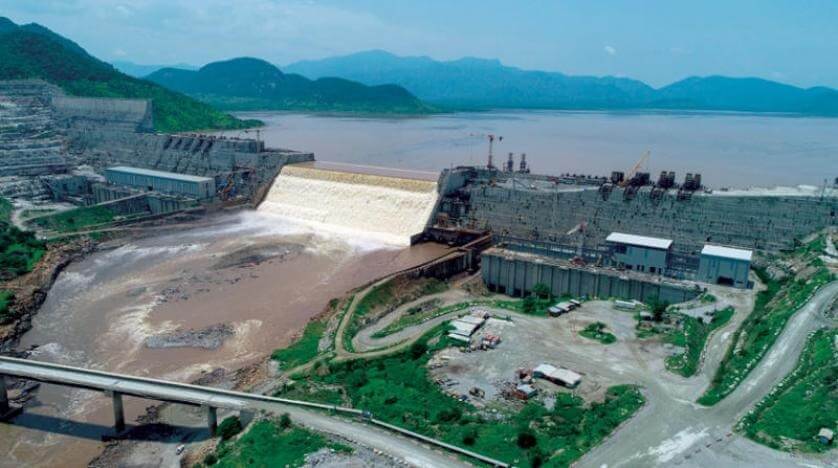
There is a huge conflict between the politics of the Horn of Africa and East Africa for many decades. The reason behind this conflict is the water sharing of the Nile. A major dispute is running between Egypt and Ethiopia on a project of $4.5 billion for the Grand Ethiopian Renaissance Dam. The project and related disputes gave birth to deep-seated fears, small wars, stoking patriotism, and national preoccupation in both countries. The other countries opposed the Egyptian domination over the river's water resources. The introduction of the Nile Basin Initiative marked a big step to generate peace among these states.
It is tried several times to solve the disputes between the countries by making agreements. On 14 May 2010, Entebbe, Ethiopia, Rwanda, Uganda, and Tanzania were the countries that signed a new agreement to solve the dispute. But Egypt and Sudan opposed the agreement. Ideally, there should be such an international agreement in which all the disputing countries can enjoy an equal and efficient use of the Nile basin's water. Suppose there will not be a clear understanding of the future water resources of the river. In that case, these conflicts can worsen among the countries which depend on the Nile not only for the water supply but also for their economic and social development.
MODERN ACHIEVEMENTS AND EXPLORATIONS
The entire Nile was navigated by the American explorer John Goddard with his two French partners in 1951. Their journey was about 6,800 km long, which started from the River's source in Burundi to its mouth on the Mediterranean Sea. They reached the final destination within nine months as described in the book named 'Kayaks down the Nile'.
- White Nile: The South African Hendrik Coetzee led the expedition of about 3,700 km long White Nile. On 17 January 2004, he began his journey from Lake Victoria, Uganda, and ends at the Mediterranean, Rosetta. They finished their journey within four and a half months.
- Blue Nile: The geologist Pasquale Scaturro and Kayaker and filmmaker Gordon Brown were the first known people who led the Blue Nile Expedition from Lake Tana, Ethiopia, to Alexandria, Mediterranean. But only Brown and Scaturro were successful in completing the entire journey. They started their journey of 5,230 km on 25 December 2003 and completed it within 114 days on 28 April 2004. The team completed a major part of their journey through outboard motors. The first human-powered transit of the Blue Nile was completed by Canadian Les Jickling and New Zealander Mark Tanner on 29 January 2005. Their 5,000 km-long journeys took five months to complete. They told about how they were arrested at gunpoint in two war zones.
|

 For Videos Join Our Youtube Channel: Join Now


