| |

Line of Control (LOC)The Line of Control (LOC) is the border-line that divides the region of Kashmir as Pak-occupied Kashmir. It is a military control part of the formal (under the British) Jammu and Kashmir between the countries India and Pakistan. This Line is not really legally accepted as an international boundary but is a substantively popular border. India controls one side of the land of the Line-of-Control, and Pakistan controls the other side. These two countries, India and Pakistan, fought in Kashmir between the year 1947 and 1948. The Line between countries marked a military front when both declared a ceasefire in January 1949. This military front day-by-day became a solid boundary called the "Ceasefire Line." The original term was "Ceasefire Line," which was officially renamed to "Line of Control" after the Simla Agreement was signed on 3 July 1972. 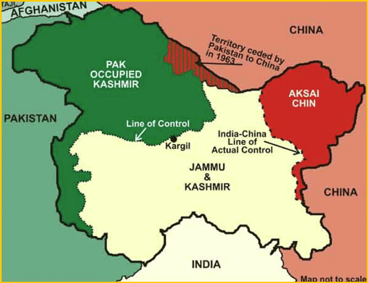
All of Kashmir has a former princely state, which is now under Indian military control, and they are known as the state of Jammu and Kashmir and Ladakh. The two parts of the land are under Pakistani control, known as Azad Jammu and Kashmir (AJK) and Gilgit-Baltistan. The India - Pakistan border starts from the southernmost part of the Line of Control and extends up to the northernmost part of LOC called NJ9842. The boundary of the Line of control is 460 mi (740 km) long. This NJ9842 India-Pakistan border is considered as the base of Siachen Glacier in the north. This borderline was based on the assumption that it is the highest point in the northward direction. However, the high mountains in the trans-Himalayan region had not yet been fully explored about the boundary. In the 1965 war, both country India and Pakistan occupied each other's region; India captured over 750 sq miles while Pakistan covered about 200 sq miles. When the Tashkent agreement was done, both militaries returned to their actual previous positions, including the Line of Control. Another ceasefire line that separates the Indian-controlled part of the state of Jammu and Kashmir from China-controlled land is called as Aksai Chin. It is from east of Kashmir and known as the Line of Actual Control (LAC). However, the other part of the land is controlled by the Indian military, but China considers this substantive line as a part of its border with Pakistan. Both China and Pakistan agreed with this border, but India did not. 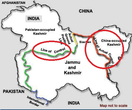
Former US President Mr. Bill Clinton once described the Indian subcontinent and Kashmir's area of Line of Control as one of the high-risk places in the world. How is a line of control formed?After the India-Pakistan division, both countries fought over Kashmir between 1947 and 1948. The area of the Line of Control was originally marked as the military front when both countries, India and Pakistan, declared a ceasefire on 1/2 January 1949. This military front slowly became a solid boundary between India and Pakistan. It was officially named and declared the Line of Control after the Simla Agreement that was signed on 3 July 1972. Indian Line of Control FencingIndia constructed a 550 km (340 mi) fence along the side of the LOC, which is 740 km (460 mi) long. It is only a part of the length of the Line, and the rest of the LOC is out of the way to construct a barrier. This fence aims to avoid arms smugglling and entering the line by Pakistan-based sectary militants. Pakistan has criticized the construction of the fence barrier. They said that it violates the bilateral agreement relevant to UN Security Council resolutions on the region. Line of Control Crossing PointsIndia and Pakistan officially selected five main crossing points after the 2005 Kashmir earthquake. These crossing points are also called passes between India and Pakistan (LOC), which are currently operational. According to the Azad Jammu and Kashmir Cross Line of Control Travel and Trade Authority Act 2016, the crossing points are Chakothi / Salamabad (URI), Titrinote / Chakan Da Bag (Rawalakot / Poonch), Chilliana / Teetwal, Tatta Pani / Mendher, and Haji Peer / Silli Kot. In these crossing points, Chakothi and Titrinote are the trade points. 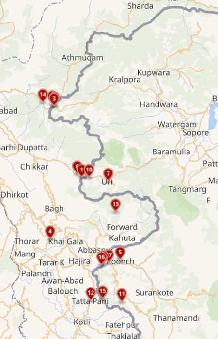
1. Chakothi / SalamabadSalamabad crossing point is a major route to cross the Line of Control for trade and travel. It is a road crossing located between Chakothi and Uri in Baramulla district on Jammu and Kashmir along the Indo-Pak Line of Control. This LOC crossing point is a major route to cross for trade and travel. It was initiated by the Indian side for banking facilities and trade activities. The route at this crossing point was opened for trade in 2008 after 61 years. Buses from Srinagar to Muzaffarabad pass through this bridge on the LOC. 2. Titrinote / Chakan Da BaghA road connects Kotli and Tatrinote on the Pakistan side to the Indian Poonch district of Jammu and Kashmir through the Chakan Da Bagh crossing point. It is a crucial by-pass to cross LoC for trade and travel. Banking facilities and trade facilitation centers are being planned on the Indian side for the benefit of traders. 3. Chilliana / TeetwalThe Teetwal border crossing pass is located across the Neelum River between Muzaffarabad (on the Pakistan side) and Kupwara (on the Indian side). It is mainly open only during the month of the summer season, and unlike the other two crossings, it is open only for the movement of people and not for trading purposes. 4. Tatta Pani / MendharTattapani and Mendhar is another border pass between the countries Pakistan and India that opened on 14 November 2005. This pass connects Pakistan-administered Kashmir at Tattapani and the Poonch district of India at Mendhar. What is the Line of Actual Control (LAC)?The Line of Actual Control (LAC) is the political border that separates India-controlled territory from the Chinese-controlled territory area. India says that the LAC is 3,488 km long, while China denies this and says that it is only about 2,000 km. The Line of Actual Control is divided into three regions on the Indian side: the eastern region spanning Arunachal Pradesh and Sikkim, the central region spanning Uttarakhand and Himachal Pradesh, and the western region spanning Ladakh. Another dispute about LAC between India and China is:
What is India's response to China's designation of the LAC?In response to China's designation of the Line of Actual Control (LAC), India rejected this concept in both wars fought in November 1959 and October-November 1962. At that time, Indian Prime Minister Mr. Jawahar Lal Nehru rejected the definition: "There is no sense or meaning in the Chinese offer to withdraw 20 km from what they call 'line of actual control.'"
Difference between LOC and LAC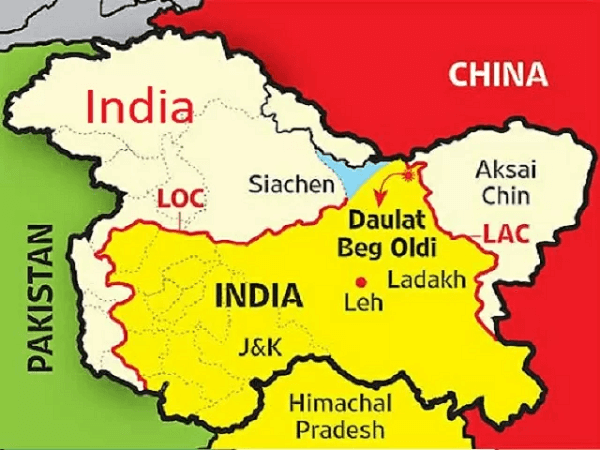
Below, we have compared the difference between the Line of Control (LOC) and the Line of Actual Control, which can help you to understand both by comparison.
|
 For Videos Join Our Youtube Channel: Join Now
Feedback
- Send your Feedback to [email protected]
Help Others, Please Share


