Difference between Globe and Map
Maps and globes are very helpful tools for locating locations on the surface of the Earth. A globe and a map are different from each other as a map diagrammatically depicts the Earth's surface on paper, and a globe is a spherical representation of the Earth. This article explains the difference between a globe and a map in detail.
Map
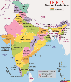
A map is a depiction or illustration of the Earth's surface. A map symbolically represents the distinctive features of a place. The different features are displayed on a map using signs or symbols. A map is typically drawn on a flat surface. Cartographers, or mapmakers, produce maps for a variety of uses. The art and science of creating maps and charts are known as cartography. Maps are easy to fold and carry, so that you can take them everywhere.
Symbols
- The map uses a variety of symbols to represent various things.
- Discrete points, lines, and colours are used as symbols on maps.
- A different type of line is used to represent roads, highways, and railways.
- Colours are used to represent physical features. For example, green for trees and forests, brown for mountains, and blue for water bodies.
Elements of map
- Data frame: The two-dimensional frame on a map is known as a "data frame," which shows layers in the same region. A map may contain one or more data frames.
- Map legend:A map legend is an explanation or table of symbols placed on a map for better understanding.
- Map title: The title is significant because it provides a summary of the map's subject.
- North arrow: A map's north arrow indicates the direction of the north on the map.
- Map scale bar: The relationship between the size of the data frame and the physical environment is explained by the map scale bar.
- Border: The map's border properly defines the edge of the area represented on the map.
- Inset map: The inset map is a small map displayed to help the reader understand the geographical context.
Types of map
- Physical map: Physical maps represent the structure of the land, including hills, lakes, forests, the shoreline etc. Different colours are typically used to represent physical features. For example, blue is used to represent rivers and lakes, and red is used to represent roads. Low-altitude locations are represented in dark green; as altitude increases, the colour changes to light green and then orange.
The physical map also has contour lines. The contour lines represent constant values like temperature, elevation, and rainfall.
- Political map: Political maps represent boundaries of areas, counties, provinces, and countries. A political map does not display topographic features.
- Topographic map: The physical characteristics of a place are represented on the topographic map.
- Climatic map: A climatic map provides information about the climates of various regions. For example, it displays places with more snow, rain, or dry weather. Areas with different climates are represented using colour.
- Economic map: An economic map displays the various resources available in the region or the main economic activities. It displays the types of crops grown and the minerals present in locations. To represent the activity or resource that is present in the region, symbols and letters are utilized.
Advantages of map
- Maps are simpler to use and more portable.
- They can depict the entire surface of the Earth or small locations with great detail.
Disadvantages of map
- Every map has distortions because a 3D object like the Earth cannot be correctly represented on flat maps.
- Maps without scale provide a poor idea of distances, so it will confuse users.
Globe
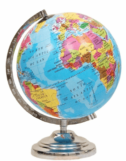
A globe is a 3D model of the Earth. A globe is a spherical representation of the Earth, and its spherical shape shows the surface's features, directions, and distances more accurately than a flat map. As per history, the first globe was created by the Greek philosopher Crates of Mallus. Globe is mounted on an axis so that the globe can rotate. Different colours represent the countries and oceans on the globe's surface. The globe is not fixed and is turned the same way as topspin, or a potter's wheel is turned.
Types of globe
- Terrestrial globe: Continents of land and sea are represented on a terrestrial globe, and it also represents countries, significant cities, and a network of latitude and longitude lines. By using a terrestrial globe, children can learn about geography very effectively.
- Relief globe: The land's features are represented on relief globes. The valleys, mountains, rivers and seas are well represented on the relief globe.
- Celestial globe: The celestial globe displays the stars' apparent positions in the sky. The physical characteristics of celestial bodies, such as the Moon or Mars, are also depicted on the celestial globe. Celestial globes are utilized for astronomical computations.
There are magnetic globes, wooden globes, paper globes, puzzle globes, heirloom globes, and custom globes available that you can purchase.
Advantages of globe
- The globe promotes visual precision.
- Globes help clarify the concepts of parallels and meridian lines.
- It shows how the Earth's axis is tilted.
- It is a small-sized depiction of Earth.
Disadvantages of globe
- Difficult to hold in the hands.
- It doesn't display towns, districts, roads, railroads, etc.
- It is useless to study a particular region of the Earth.
Difference between Globe and Map
Here are some major differences between a globe and a map.
| Globe |
Map |
| A map is a scaled representation or sketch of the entire Earth's surface or a section on a flat surface. It might be hand-drawn or printed. |
A globe is a spherical representation of the Earth. |
| Globe is a 3D sphere. |
A map is a 2D rectangle. |
| A globe can provide a broad overview of the planet. |
The map offers more specific information about certain locations. |
| A globe revolves around an axis because it is spherical. |
Maps are represented on a piece of paper. |
| Globes are challenging to transport since they are made of non-foldable materials. |
You can easily fold maps and carry them wherever you go. |
| Globes don't provide enough specific information to help in navigation. |
The map is utilized to go from one place to another. |
| The location, direction, and other geographic information are displayed on globes. |
There are many distinct types of maps, including physical maps, political maps, road maps, etc., each used for a certain purpose and depicts different geographic features using various signs and symbols. |
| It displays a few details only. |
It displays a lot of information. |
|

 For Videos Join Our Youtube Channel: Join Now


