TYPES OF PRECIPITATION
The condensation of atmospheric water vapor from clouds that come to the earth due to its gravitational force in the form of rain, freezing rain, snow, sleet, hail, etc. Precipitation plays a massive role in the completion or continuation of the water cycle by delivering the atmospheric water in its original form or some other forms to the earth. A significant part of precipitation or the premium product of the water cycle is rain. Some people may often think that precipitation is something that falls from the clouds. Instead of this, when a solid settles to the bottom of a solution in a chemical reaction is also called precipitation.
Precipitation is when the water condenses due to the saturation of the atmosphere with these water vapors that results in the fall of water to the ground. The mist and fog are not taken as part of precipitation but colloids because water vapor does not condense sufficiently to precipitate.
The various sources of fresh water on the earth are deposited by the rain, a significant water cycle component. Each year approximately 505,000 cubic kilometers of waterfalls on the earth in the form of precipitation.
DIFFERENT FORMS OF PRECIPITATION
Several types of precipitation are as under:
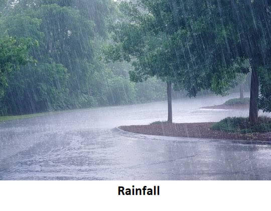
- Rain: It is the form of water droplets that fall on the surface of Earth. These liquid droplets fall from clouds that are present in the sky. They can be 0.5 mm or larger in diameter. When many small clouds, particles strike and bind together, the more effective raindrops form. The process remains until the drops do not get heavy enough that the air can't hold them, and the earth's gravitational force can pull them down.
At the beginning of their journey to the earth's surface, these droplets are present in the form of ice crystals or snow due to low atmospheric temperature. But as they proceed down, the ice or snow melts for the warmer air and converts into droplets. The rate of rainfall varies from time to time and area to area. Rain is essential to complete the water cycle by replenishing the sources of underground water and freshwater. RA is the METAR code for moderate rain, +RA for heavy rain, while SHRA for rain showers.
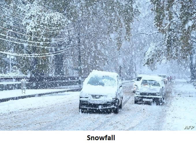
- Snow: The formation of snow takes place almost whenever the rain falls. However, before reaching the surface, it often melts. This form of precipitation is visible in the form of virga or flakes made up of ice and generally falls from the cirrus clouds, which are high, thin, and weak clouds. The snow is formed in these clouds when the atmospheric temperatures reach above freezing. But this occurs mainly in sub-freezing air. The snowflakes melt partially when the temperature is above freezing. But at the same time, the immediate evaporation of particles occurs due to the presence of relatively warm air. Because of this evaporation, the atmosphere around the snowflakes remains cool, which helps them in reaching the ground in their original form. This snow can be of different shapes like flat plates or thin needless. It has a fluffy, white, and soft structure. The atmospheric humidity and temperature both are responsible for the formation of snow. This process of snow precipitation is generally called snowfall. METAR code for snowfall is SN.
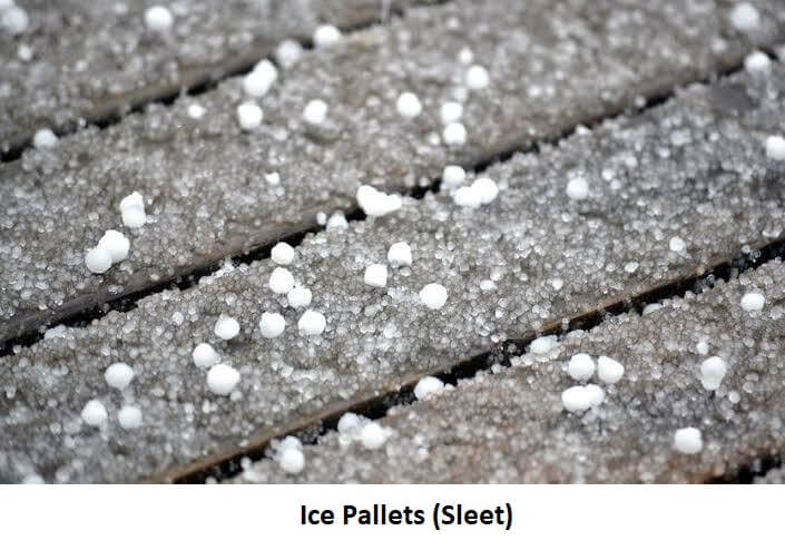
- Ice Pellets (Sleet): Ice pellets are small, translucent balls of ice that are not similar to Graupel. The size of these balls is comparatively smaller than hailstones. These frosty white rims are made from a slushy liquid or semi-solid, which is a mixture of rain and snow. After hitting the earth's surface or any other solid object, they bounce back. Their pitch of "tap" sounds higher than the dull splat of raindrops after touching the objects like dried leaves, windshields, and jackets. Only after mixing with freezing rain pellets can freeze and turn into a solid mass.
When the layer of above and sub-freezing air exists together both above and below, the sleet formation occurs. In other words, when the atmospheric conditions are freezing, then sleet forms. The snowflakes that fall from the warm layer melt partially or entirely. When these melted snowflakes reach the sub-freeze layer, they re-freeze into ice pellets. If the sub-freeze layer is too small, then the precipitation will not freeze again, resulting in freezing rain at the surface. Their METAR code is PL.
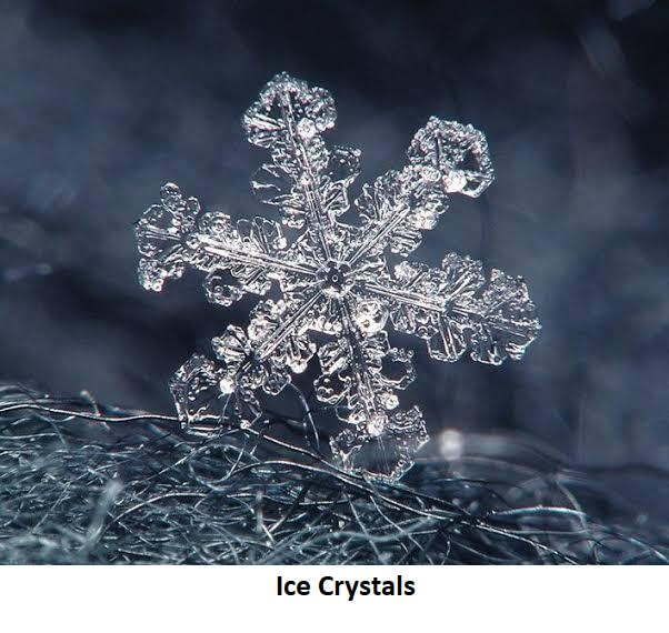
- Ice Crystals: These are solid ice that displays atomic ordering on various length scales. Ice crystals include hexagonal plates & columns, diamond dust, and dendritic crystals. The direct deposition of water vapor onto the ice crystals causes their huge symmetric shapes. The environment temperature and humidity led to the development of these crystals into various symmetric shapes. These shapes can be needless, columns, dendrites, and plates. There can be a mixed pattern of the environmental conditions change due to the migration of crystals.
The ice fog and cirrus clouds contain the ice crystals. The slight whitening of ice crystals indicates that the moist air is moved to a high level, i.e., troposphere, and freezes to ice crystals which is the sign of the weather front's arrival. METAR code for ice crystals is IC.
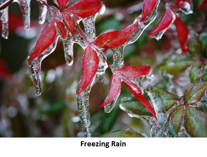
- Freezing Rain: When the rain falls below the freezing temperature, the freezing rain happens. Usually, this is the result of the solidification of rain droplets. These droplets get supercooled when they reach into the sub-freezing layer in the atmosphere, and these drops freeze when they touch the earth's surface. This can be seen in the form of a thin layer of ice on cars, streets, trees, and power lines. This ice-fishing is known as glaze ice. The glaze over these things is caused due to the freezing rain. The thickness of the glaze can reach several centimeters. Freezing rain has a significant threat and affects the day-to-day operations of roadways transportation, power lines, and aircraft. The freezing rain makes the road slippery, which can cause a severe accident. -FZRA is METAR code for light freezing rain, while FZRA +FZRA is METAR code for moderate to heavy freezing rain.
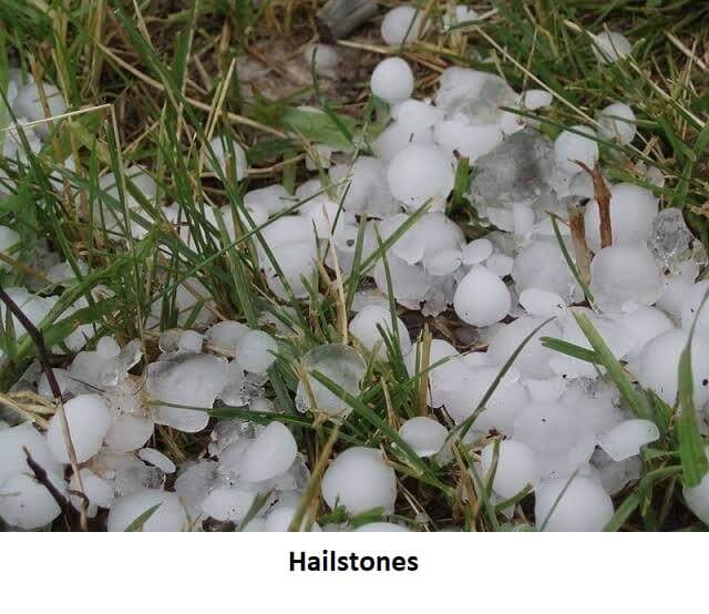
- Hail: The big balls and irregular lumps of ice are known as hailstones. This solid form of precipitation falls from a large thunderstorm. The hails formed during the winter. When they fall on the earth's surface, their diameter can be between 0.2 inches (equals a pea's diameter) to 6 inches (equals a grapefruit's diameter).
They are highly damaging to the standing crops as they may reduce their quality and tear the leaves. The ice can be held against the earth's gravitational force by violent thunderstorms that have potent updrafts. This brings hailstones to the ground when they eventually escape. Hence, it's clear that hailstones are the supercooled droplets. These droplets freeze slowly and become a sheet of clear ice. Their METAR code is GR.
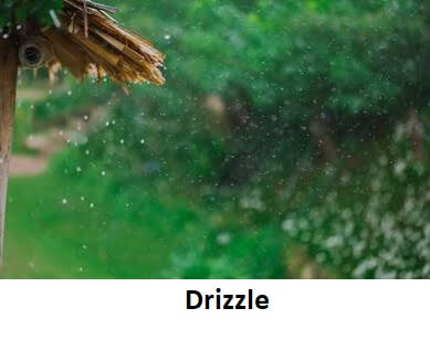
- Drizzle: This is very light rain. Drizzle is less than a shower but more than a mist. A thin form of fog with condensation near the earth's surface is called mist, while cloud water droplets or ice crystals suspended in the air, close to the ground, is called fog. The diameter of drizzle droplets is less than 0.5 millimeters. The rise of drizzle happens from losing stratocumulus clouds. Due to a minimal size, these droplets may also evaporate before reaching the surface. In the cold atmospheric temperature, they can be persistent. The METAR code for drizzle is DZ.
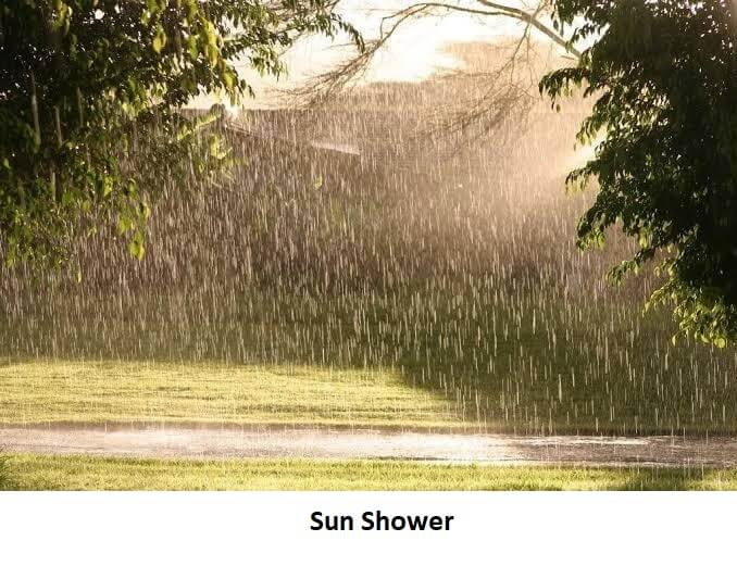
- Sun Shower: This is a form of precipitation in which the sun shines at a rainy time. This is a situation when the rain occurs without the presence of clouds. The rise of these raindrops can happen when the rain is brought several miles away by the wind, along with the rainstorms in the area without clouds. So in the absence of clouds, there will be the sun shining, and as the rain brought by wind, there will be the shower. Hence the condition is called a sun shower.
Consequently, this form of precipitation forms when a single rain cloud passes away from the ground and the penetration of the sun's rays takes place through the raindrops. Mainly, this condition is caused by the formation of a rainbow.
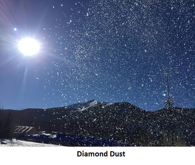
- Diamond Dust: These are a minimal form of ice crystals that have a hexagon shape. Diamond dust is usually formed at low levels and when the temperature is less than -30° C or -40° C due to the mixing of slightly higher moisture air with colder surface-based air. When the light reflects on the crystals of ice in the air, the sparkling took place. Its name originated from this sparkling effect. In the international hourly weather report, IC is the METAR identifier for diamond dust.
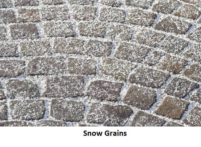
- Snow Grains: Tiny white and blurry grains of ice are called snow Grains. Generally, their diameter is not more than 1 mm. Their shapes are flat and elongated, and their size is almost the same as a drizzle. They don't bounce back after touching the earth's surface and mostly fall in various small quantities. The source of their arrival is stratus clouds or fog. Snow Grains never fall in the form of a shower. Their METAR code in SG.
- Occult Deposition: The occult deposition takes place when the air or mist contaminated with water vapors move over land, trees, and shrubs. This is also called the deposition of acid compounds. This led to a direct and high impact on the vegetation, buildings, etc., due to the high level of concentration.
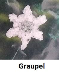
- Graupel: Graupel is also called hominy snow, soft hail, and snow pellets. They form by the collection of supercooled water droplets, and they are frozen on falling snowflakes. This makes a form of crisp, opaque rime that has the size of 2-5 mm.
Graupel is different from ice pellets and hail. Hails fall in thunderstorms while Graupel falls in winter storms as well as in connective showers. GS is the METAR code for Graupel.
Under some specific atmospheric conditions, snow crystals may encounter supercooled water droplets. These droplets can exist in the liquid state at a temperature of -40 °C. When these droplets come into contact with snow crystals, they freeze on their surface and make the crystals rimed. This process is known as accretion. The process changes the appearance of the crystals. This new form of snow crystals is called Graupel.
CAUSES OF PRECIPITATION
- Orographic Effects: The windward side of mountains gets the orographic precipitation. The condensation and adiabatic cooling caused by the large-scale flow of rising air motion of most air across the ridges of mountains generate the orographic precipitation. Compared to the leeward or downwind side, there is more consistent wind, a more moist climate on the windward side of mountains. The descending side gets the drier air due to the removal of moisture by orographic lift, and on the leeward side, a rain shadow is observed.
An example of the orographic effect is the Himalayas mountains in Asia. The mountains are an obstacle in the path of the monsoon that causes extremely high precipitation on the southern side while lower precipitation on the northern side.
- Convection Uplift: Convection Uplift is responsible for the formation of cumulonimbus clouds and cumulus clouds. This convection uplift occurs due to the upper movement of warm air. By the process of adiabatic cooling, the air that moves upward becomes This helps in the formation of clouds and precipitation also.
When the ascending air mass is warmer than the surrounding air or unstable, the formation of cumulonimbus clouds happens due to this connection uplift. On the other hand, the formation of cumulus clouds happens when the ascending air mass is stable and its temperature is the same as the surrounding air masses.
- Within the Tropics: During the rainy season, most regions get the average annual rainfall within one or more months. The season is sometimes also called the green season. The tropic and subtropic areas get dispersed during the wet season. In the tropical rainforests, there are not dry or wet seasons as they get rainfall throughout the year. Tropical cyclones cause hefty rainfall. These cyclones have large air masses that can move to several hundred miles. A cyclone has low pressure at the center and with winds blowing inward towards the center. The direction of wind flow can be either clockwise or anti-clockwise.
- Snow: Cold and dangerous conditions with heavy rain, snow, and winds (exceeding the speed of 119 km/h) can be brought by extratropical cyclones. A significant difference is created between ample water such as lakes and the air above. This is because the lakes can store efficient heat. This difference between temperatures is responsible for transporting the warmth and moisture upward and condensing it into vertically oriented clouds. These clouds produce snow showers. At a high level, the temperature decreases, directly affecting the depth of clouds and precipitation rate.
In the mountainous regions, when the air ascends the mountains and their windward slopes, it squeezes out precipitation, and heavy snowfall occurs.
- Large Scale Geographical Distribution: In the North and South regions of Colombia, the amount of precipitation is due to the formation of ridges caused by descending air. This region develops most of the earth's deserts. While its mountainous regions, located near the equator, are among the earth's wettest areas. Hawaii is an exception here because it is also among the wettest locations on the planet due to the upslope flow of the trade winds. Asia gets a tremendous amount of rainfall in northeast India during the wet season due to the flow of moist air.
|

 For Videos Join Our Youtube Channel: Join Now


