| |

Soil ConservationSoil Conservation is used to protect the soil from degradation. It prevents the loss of the soil's topmost layer from erosion or reduced fertility caused by over-usage. Soil conservation involves treating the soil as a living ecosystem. It means returning organic matter to the soil on a repetitive basis. Soil conservation is about solving the problems of land degradation, particularly accelerated soil erosion. Accelerated soil erosion results from the physical forces of wind and water on the soil, which has become vulnerable because of human interference with the natural environment. Due to this, soil erosion can be viewed as a symptom of bad land use and management. Soil conservation is fundamentally a matter of determining a correct form of land use and management. A correct form of land use and management provides a higher level or a different form of productivity. Soil conservation can be defined as the combination of the appropriate land use and management practices that promote the productive and sustainable use of soils and, in the process, minimize soil erosion and other forms of land degradation. Soil conservation is an active ongoing process defined in the following steps, such as: Step 1: The first step is to obtain a good basic knowledge of the land resource. It means knowing where the soil is most permeable and susceptible to groundwater contamination from excess pesticides. The land is most susceptible to water erosion because of a combination of slope and soil texture. Without this understanding, it is impossible to plan an appropriate conservation strategy. Step 2: The next step is identifying or predicting problem areas, choosing and implementing soil conservation techniques, and maintaining control structures. Step 3: The final step is to continually monitor the plan's effectiveness and make changes if necessary. Importance of Soil ConservationIn India, out of the total geographical area of 329 M-ha, about 150 M-ha areas are subjected to either water or wind erosion. A net area of about 140 M-ha is cropped at present. It is estimated that about 175 M-ha of the country's total geographical area is subjected to various soil and land degradation problems such as saline-alkali soils, waterlogged areas, ravine and gullied lands, an area under shifting cultivation, and desertification. The cropped area is shrinking every day, which means the limited land resource must be managed very carefully by adopting full conservation measures to survive the huge population. Here are the following important points to conserve soil and water resources in Indian, such as:
Soil Conservation TechniquesFollowing are some common soil conservation techniques. 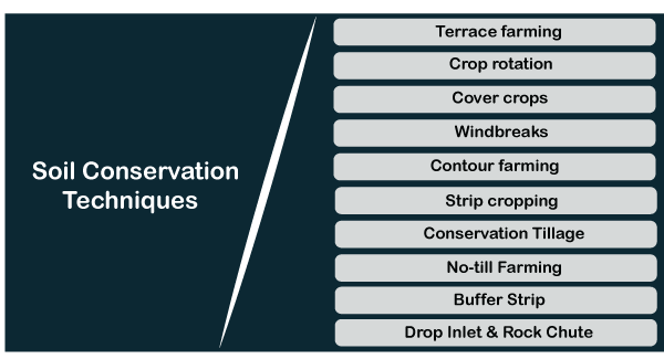
1. Terrace FarmingA terrace is a practice of creating nearly level areas in a hillside area. The terraces form a series of steps, each at a higher level than the previous. Terraces are protected from erosion by other soil barriers. Terraced farming is more common on small farms. There are several design options, but both the ridge and channel are permanently grassed. Terraces are designed to intercept runoff on a slope and reduce its erosive action on the soil down the slope. Water is channeled slower along the vegetated channel to a safe, stable outlet such as a grassed waterway or standpipe or drop inlet. 2. Crop RotationCrop Rotation is an alternative to planting a field in the same crop year after year. It is also known as continuous mono-shelterbeltsculture cropping. Instead, the main crop is rotated, ideally with cereal crops like winter wheat or forages such as clover and alfalfa. Crop rotation provides several benefits. Rotation reduces the risk of insect and disease problems, so decreasing pesticide dependency. Because the crop is changed each year, pests do not have enough time to establish damaging numbers. 3. Cover CropsCover crops are crops planted to reduce the impact of wind and water on bare soil. They absorb the impact of rain, reduce runoff's speed, hold the soil in place, and encourage greater infiltration. Sweet clover, alfalfa, rye, and winter wheat are common cover crops. They are planted on areas susceptible to erosion like steep slopes, stream and river banks, and grassed waterways or around wells to protect groundwater supplies from contamination. Winter wheat is often planted to cover the winter and 95 to 100 percent erosion control during the spring runoff. Intercropping involves mixing plants in a field. This technique may be used by a farmer who cannot afford to take his or her entire crop of corn out of production. 4. WindbreaksA windbreak or shelterbelt is a vegetation barrier designed to reduce or eliminate the wind's velocity and reduce wind erosion. Windbreaks are also used for snow control and to provide shelter for buildings and livestock. A distinction can be made between windbreaks and shelterbelts. Windbreaks consist of one to five rows of trees or shrubs, and shelterbelts are six or more rows wide. Windbreaks are generally planted on the west, southwest, or northwest boundary of a field to protect from prevailing winds. The protection is maximized downwind of the barrier, where the wind speed is significantly reduced from 15 to 20 times the trees' height. The windward side of the break receives protection for 3 to 5 times the total height. The benefits of both windbreaks and shelterbelts extend far beyond just erosion control. Crop quality and livestock performance are improved due to less abrasion from blowing soil. Tree and shrub row significantly increase the landscape's aesthetics, which is proven by higher land values. A major benefit of windbreaks is their enhancement of wildlife habitat. They provide places to roost nest and seek cover from predators from the winter climate. 5. Contour FarmingContour farming involves tilling and planting along the contour, rather than up and down the slope. The furrows and rows of plants act as dams that slow down water flows moving down the slope. Unless some contour farming is used, particularly on long slopes, serious field erosion can result. Contour farming also uses less fuel and power for tractors. 6. Strip CroppingStrip cropping involves alternating small grain (rye) strips or forages crops (clover) with row crops like corn. It is used to control erosion by reducing the velocity of wind and water. The forage and cereal grain rows tend to trap sediment that may otherwise end up in watercourses. Strip cropping is most effective in controlling erosion on a slope when placed along the land's contour. It works best if the strips are placed at right angles to control wind erosion in the prevailing wind direction. Another benefit of strip cropping is the organic matter added from the forage or cereal crop rows. 7. Conservation TillageConservation tillage consists of a variety of practices used in agriculture to reduce wind and water erosion. Bare soil is highly susceptible to erosion. Excess tillage destroys soil structure and organic matter. At least 20 to 30 percent of the soil surface is covered in the previous year's crop residue after planting in conservation tillage. The residue reduces wind velocity at the soil surface and breaks the impact of raindrops. Root systems hold the soil in place if practiced across a slope, rows of stubble act as small dams to slow water as it runs downhill. 8. No-till FarmingNo-till farming involves planting seeds into the residue of the previous crop, with no-tillage between harvests. No-till leaves 60 to 70 percent of a field covered with crop residue. Another aspect of conservation tillage is the choice of machinery used. The traditional moldboard plow tends to overturn and throw the soil leaving it bare and exposed to erosion. Chisel plows leave 30 to 50 percent of the soil surface covered with residue. Soil should not be tilled and traveled on when it is wet. This practice is the leading cause of soil compaction. One of the major advantages of conservation tillage is increased water infiltration, a greater addition of organic matter to the soil, and fuel and time savings. Conservation tillage also enhances wildlife habitat for soil organisms, birds and small animals like field mice and snakes. 9. Buffer StripA buffer strip is an area of land adjacent to a watercourse vegetated with grasses or bushes. The plant cover filters sediment out of runoff holds the soil in place, and prevents washout, slumping, and water quality reductions due to siltation. Buffer strips are generally 2 to 5 meters wide. They should be protected from tillage, machinery and cattle access to work effectively. Buffer strips provide excellent wildlife habitat for small animals and insects. If forested, they can improve stream habitat by shading the water and making the environment more suitable to fish species like trout. The leaves that fall into the water provide organic matter for small stream invertebrates, which are, in turn, food for larger stream animals like crayfish. Stream-side forests are extremely productive habitats for wildlife, and like shelter belts, they also improve the aesthetic quality of the environment. 10. Drop Inlet and Rock ChuteA drop inlet consists of a vertical intake pipe and a horizontal underground pipe. The water enters the vertical pipe at the ground surface and falls below, where it is guided safely through a large concrete metal or plastic pipe into a stream or ditch. And a rock chute is a pile of rocks designed to move concentrated water flows over steep slopes. Drop inlets and rock chutes are often used to step water down where there are rapid elevation changes, thereby protecting soil from erosion. Soil Conservation ProgramsMainly three ministries are implementing various watershed development programs, Ministry of Agriculture, Ministry of Rural Development & Ministry of Environment & Forests, to develop degraded lands. These programs are listed below:
Need for Soil ConservationThe basic needs of soil conservation remain to enhance and maintain agricultural productivity in a cycle with the general agro-socio-economic practices in the respective region. However, the specific objectives of soil conservation are as follows:
Next TopicWhat is Security Operation Center?
|
 For Videos Join Our Youtube Channel: Join Now
Feedback
- Send your Feedback to [email protected]
Help Others, Please Share


